My name is Jason and this blog is about bikes and biking, plain and simple. I don't claim to be a gear head, a former pro, a hipster or an afficionado. I just like to ride my bicycle.

Wednesday, September 8, 2010

Day 5: Gunnison to Crested Butte to Kebler Pass

Miles traveled: 28 to CB and another 7 to top of Kebler Pass
Ride time: 1:59 to CB and about :54 to Kebler
Average speed: 14.1

I got out of bed at 7:30, a comparatively late start for me. It took me a while to get my gear in order and carefully packed into the panniers. Today I found myself blessed with more leisure than I have thus far allowed. After talking with Amy and Caroline for a little while I left the hostel and rode towards Main Street in Gunnison: the road to Crested Butte. I found a helpful guy at a second hand outdoor gear store who let me use some chain lube; silencing the hamsters if but temporarily. I stopped back by The Bean for breakfast and blog updates. For the sake of diversity I probably should have gone somewhere else, but this repetition proved fortuitous for me. As I left the store and walked my bike north towards the street I passed another outdoor store and I suddenly realized that I could get another backpack meal for tonight’s camping near Crested Butte. I ate the ‘emergency’ meal I packed with me for dinner on Monarch so passing the store gave me an opportunity to replenish; Spicy Mexican Chicken and Rice is on the menu.

First I will say there was no wind. There might have been a bit of a tail wind at times, but really no wind or other atmospheric disturbance to speak of the entire ride up to Crested Butte. I enjoyed the reprieve immensely. Winding its way north along the river and through shallow canyons of rocky outcrops, the highway climbs gently towards the mountains. There are several large ranches along the route, each boasting a fresh cutting of hay now rolled into large round bales and stacked in massive piles in the fields. Caroline told me that the Gunnison area had experienced a wetter than average summer this year, the bounty of which clearly showed in the piles of hay, lushness of the grass and still green leaves on aspens and cottonwoods. The trees betray a faint hint of fall with a spattering of gold colored leaves. With the cool morning air and clear blue sky above it stands to be a rich season for aspen viewing in the Gunnison valley.

The Gunnison River valley looking towards Crested Butte
When I got to Crested Butte I quickly found the Visitor Center, changed clothes and sought the advice of the guy attending the office. He provided useful information about my intended route up Kebler Pass as well as advice on what to do in Crested Butte for 3 or 4 hours. He stopped short of suggesting mountain biking, given my obvious bike-ed-ness, but before I left did tell me where mountain bikes could be rented if I found myself interested. Apparently you don’t bike to Crested Butte, you come to Crested Butte (in the summer at least) to bike.

The main street in Crested Butte is home to many shops, eateries, bars and whatnot. There were people everywhere, and it was very difficult to discern local from tourist. Everyone seemed to know each other, and everyone was also very interested in talking. I don’t know if I’ve ever been to a friendlier place. In fact here are some general rules of thumb on Crested Butte-ers:
  • A Crested Butte-er can generally be seen riding a bicycle around town. They seem to prefer cruisers adorned with plastic flowers or other such decoration, though I imagine many of them also keep a spare MTB or three for different occasions.
  • Crested Butte-ers will generally say “hi” to you and make eye contact.
  • Crested Butte-ers apparently like bike tourists. Some have a bad sense of geography as one thought the Kansas border was “like 800 miles away or something.”
  • A Crested Butte-er likes its beer. They can be found drinking them quite early in the afternoon.
  • I have a feeling many Crested Butter-ers work two or three jobs to allow them to live in Crested Butte. Seems to go with the territory.
  • Crested Butte-ers will pass a cyclist on a dirt road very slowly and will generally wave. This goes for Subaru driving, mountain bike toting Butter-ers or ATV hauling, Republican bumper sticker toting ones.
  • Crested Butter-ers are friendly folks, two construction guys held up 4 other cars traveling Kebler Pass just to let one bike rider through. There’s a lot to be said for whatever’s in the water up here. If only there were enough to go around.
When I was on the eastern plains and would tell people I was riding across Colorado they were quite impressed with the feat and seemingly couldn’t fathom the idea. In Gunnison or Crested Butte on the other hand the first question people would ask is “Are you riding across the Country?” In a hotbed of outdoor enthusiasts and adventurers my little trek barely raises the seismograph of awesomeness. Maybe if I fight off a bear or build a school for blind children or something it might make the charts. Nonetheless in Crested Butte people were very interested and excited about my trip. I got stopped on the street a couple times. I had some guy interrupt a conversation with a friend to ask me about my trip. Everyone wished me well and was full of helpful advice. I wandered around the town for a while, ate a really great sandwich for lunch (I foolishly forget the name of the place or I’d plug them here…natural bakery in CB) and stopped at the Oven for a beer on the patio. I soaked in the relaxed ambiance of the town as much as I could as it resonated greatly with the theme of my day. When the afternoon grew a bit long, and the clouds began to build, I decided to hit the road up Kebler Pass.

Jail turned theater in Crested Butte

The whiteboard next to the tinfoil covered bike reads, "We know you love our bikes, so do we. Please don't ride them."  I was tempted.

Mt. Crested Butte, resort is on the backside
I wasn’t sure what to expect in planning this option for my route across the state but was quite glad I decided to do it. Although most of the road is dirt, the road really is well cared for and compacted enough to almost feel paved at times. I was warned by the fellow at the Visitor Center about the dust…which proved to be an accurate warning. He indicated that tourists and more importantly construction workers would be the worst: he was dead right in his foreshadowing of my ride. I was passed by a couple construction or commercial vehicles who must have thought it their mission to choke me to death with dust. I also got some rude passes by obvious out of towners. I could tell the Crested Butters, they would always slow WAY down and wave.

I got up to the top of the pass quickly. One guy told me that it would be about an hours trip he figured giving the heft of my rig: he was right. The road never really climbed steeply, aside from the first half mile, so I made great time, and as was suggested found a nice camp spot near the road just along the top of the pass. I set up camp quickly, changed clothes and went for a quick hike. At this point the clouds were thick and promising rain. I hiked around the remains of the Irwin mining cemetery up here near the top of the pass and saw a number of different birds. They seemed to be everywhere, but with the absence of light I couldn’t get any decent pictures of them. I turned around and headed back to camp just in time for the first drops to start falling. I’ve more or less been in my tent relaxing and reading ever since. Now that I’ve run out of ambient light I’ve turned on the pc and plan to end my night with this post. Good night. Its on to Paonia in the morning.
Top of Kebler Pass looking towards CB...ominous rain clouds.
Road down from Kebler Pass towards Paonia

Monument at Irwin Cemetary at the top of Kebler Pass

Tuesday, September 7, 2010

Day 4: Monarch to Gunnison

Miles traveled: 54
Ride time: 5:14
Average speed: 9.48

When you spend several hours fighting a headwind with panniers acting as sandbags weighing you down, you can’t help but begin to think you brought too much stuff. That thought crossed my mind more than a dozen times over the course of the day yesterday. Why did I bring all this stuff? Why did I pack this, why that? Many of the things I second guessed yesterday as superfluous junk got called into action Sunday night. So while I might begrudge the weight I suppose it’s a necessary evil.

I went to bed early Sunday night and there wasn’t a cloud in the sky. Promptly at midnight I heard the tell tale tapping of heavy drops on nylon canvas: damn. As with the previous nights I didn’t put my rain cover on the tent. I also left all my bags out, whereas previously I stored them under a tent or picnic table. For a tired bike rider I moved pretty quickly to pull out the rain fly for the tent, assemble it and move all of my bags to its dry confines. I also got out the ‘superfluous’ tarp to cover my bike to keep its gears and chain dry; its already squeaking like a pet store worth of hamster wheels so I thought drier would be better. All that extra weight now called to duty, like the army reserves of miscellaneous gear. Shortly after I got everything properly stowed away the rain stopped…go figure. Thankfully (only thankfully because I like being right) it started raining again, this time with earnest, about 1:00am.

Despite my midnight revelries I was up promptly at 6:30. I wanted to be up and on the road to the top of Monarch before the Labor Day traffic crush started. I’m glad I made this decision, I enjoyed relatively free streets for my slow spinning and wobbling up to 11,000+ft. It took me 2 hours to go 10 miles up to the top of the pass, but I made it by god. I was thrilled when I reached the little parking lot at the top. I took some pictures, put on some more clothes and then started my descent. The first thing that hit me on the way down was the cold: bone chilling cold even with a jersey, arm warmers and jacket. The second thing was the wind: damned infernal wind. Despite the lack of physical comforts on my descent, I didn’t pedal once for 7 or 8 miles, with the exception of shifting my down-pedal leg for the turns. The Surly under duress handled the curves and steep grades with ease. I stopped briefly at Sargents to dance around in a circle for warmth and then set out on the road to Gunnison. It took 3 hours to cover 24-ish miles. I’d crest hills and have to stand up and sprint to keep the wind from shutting me down altogether.

When I finally got to Gunnison I came across a couple from Czechoslovakia who were riding from Denver to San Francisco. They were well outfitted with nice gear and lightweight aluminum bikes, but still were quite finished with the wind about as much as I was. I talked to them for a while about their trip, gear selection, weight of bikes etc. We then parted ways as they were heading onward out 50 west and I was planning on heading north to Crested Butte. They were the second group of bike tourists that I’ve seen. On Sunday heading up Bighorn Canyon to Salida I saw three riders heading the other direction. We exchanged quick hellos and that was it. The nice lady at the Gunnison Visitor’s Center gave me some information on national park camp grounds which were several miles away (no), the KOA out west past town (no thanks), and a hostel in town (bingo). I opted for a bed, warm shower and proximity to dinner.

The Wanderlust Hostel in Gunnison was quiet with no other guests, so I chose the dorm room option but ended up with the equivalent of a private room. The price was less than my cheesy Royal Gorge campsite, and while the scenery wasn’t quite as nice the comforts of home weren’t far away. The eclectic décor, hot showers, movie cabinet, wi-fi and stocked pantry made the Wanderlust an ideal destination for my halfway point. It was a great place to relax (sitting in the hammock in the yard) and recharge a bit. Amy, the owner of the hostel, and her mother Caroline run a really nice retreat for the weary traveler. I spent my afternoon in Gunnison lounging around, went out for pizza and a beer at Marios and then returned to a warm spot on the couch with Cole the dog as my attendee.

So now I’m in somewhat of a chill out mode of my trip. At 321-ish miles I’m more than halfway through and yet have a number of days to finish out my tour. My goal at the onset was to really push to get out to this part of the state and spend some time taking in the Gunnison area, Crested Butte and Paonia. At this point I don’t have to hurry and with the exception of one day (the push to Grand Junction) I shouldn’t have any day totaling more than 50 miles unless I get a wild hair. So as I finish this post, and sip my coffee, I’m contemplating all the options yet to come: wandering through Crested Butte, camping out near Kebbler Pass, perhaps a hike…its going to be a good week.
The long and winding road...looking back down the canyon.

The little pink signs in the background warn cyclists about parking their bikes on the walkway. As if that's the only thing to worry about at the top of a mountain pass...geesh.

Top of Monarch Pass and the Continental Divide!

Monday, September 6, 2010

GUNNISON

So I'm at The Bean in Gunnison downing a turkey sandwich on some really tasty whole grain bread. I survived the climb over Monarch. It wasn't pretty but I did it. I withstood 3 hours of 8mph fighting against the high plains wind. It wasn't pretty but I did it. And now I'm glad to be here in Gunnison, off my bike and fed (at least temporarily). I'll write more about my reflections on the day's events, as well as post some pictures in another post. I got the post up from yesterday's travails so that will have to suffice for now. In the meantime I will say this about Gunnison. Its a small place but per capita, or per road mile, it must have more bike lanes than Portland. I can get behind that. Secondly, many places in Gunnison are closed on Monday. I don't know if I can get behind that exactly.

Tomorrow its on to Crested Butte.

Day 3: Royal Gorge to Monarch

Distance Traveled: 62 miles

Ride Time: 6:17
Average Speed: 9.89 mph

At this moment I’m sitting next to a stream at the base of Monarch Pass. I am tired. My trepidation about what lies in store for me tomorrow on the slopes of the pass however has dissipated. It may be hard but I know I’ll get over it. I’m just in that frame of mind now after today’s effort. Today was supposed to be an easy day. A casual ride up the canyon to Salida, about 47 miles total; a piece of cake. In fact the day started out according to plan. From the camp ground high up near Royal Gorge the highway took a screaming 6% grade descent down to the Arkansas river. It was 2 miles of downhill. I loved every minute of it.

From there I pedaled up canyon following the river through some of the most scenic terrain of my trip. Bighorn Canyon winds along the roaring Arkansas as a channel of granite and conglomerate stones. It reminded me of the area around Buffalo Creek and Deckers; in fact it should have because I was heading through the same general region of the front range. I felt like an actual bike tourist for the first time in my trip. No agenda, no real purpose or mission just pedaling and taking in the scenery at my leisure. I found scenic places to take pictures. I read information signs. I epitomized aimlessness in all its glory. Still enjoying my trek, I stopped at Texas Creek, about 20 miles up road from where I started and had breakfast. From my table in the café I could see the trees outside begin to lean and shake in the wind. I looked away for a bit back towards my pancakes and coffee and then a cloud of dust blew down the canyon and caught my eye. I looked up and saw a small dervish of wind and dust spinning past.

Enjoying some pre-wind bike touring
For the next 32 miles I’d be plowing into some of the strongest winds I think I’ve ever ridden against. The bulk and heft of the bike with its 4 pannier sails on each side pushed and fought the wind with each surging gust. I couldn’t help myself but at times I just found myself yelling. Yelling at whom exactly I can’t say, but yelling and imploring the winds to cease. At times it was an effort to make 6 mph. At other times the winds would subside and I’d push hard to make up ground before the next blast hit. I started playing little games with myself, bartering breaks and stops at key mileage points. I passed Cotopaxi but stopped at the store in Howard to grab some cold water and a popsicle (one of my deals with myself.) The lady behind the counter commented on the wind and informed me that it is frequently blustery in the Bighorn. Why it was just the other day that “some guy came through on his way from Pueblo and said, ’I’ve fought a headwind since Pueblo. I can’t go anymore.’” Not wanting to be another one of those anecdotes I said my thanks and got moving again.

Eventually I neared Salida and was immediately uplifted. I rode into the downtown area and stopped at an outdoor store to inquire about options for camping in town. “Well you can go to Big Bear, just a couple miles east of here on 50.” No, I informed him, east wouldn’t do. What about west? “Well there’s not much until you get to Monarch.” He showed me on the map where a couple campgrounds were, all located miles off of 50 about 10 miles west of town. At that point I don’t know what it was but I just got on my bike and started riding again. It was still relatively warm; still windy as ever. I stopped at a gas station to get water for my bottles, ate a bar and some fruit leathers and kept going. It was early enough in the afternoon (around 3:00) that I guess I just decided I could keep riding. My plan was to head up towards the pass and find a spot where I could. I packed some freeze dried food for just such an occasion and with a pit stop in Poncha Springs for water and some breakfast items I pointed the Surly uphill.

So at this point I’m down a small off shoot of 50, a gravel road that leads to an old hydro electric station, now just a reservoir for fishing and place where people have obviously camped before me. I think I’m about a half mile from Monarch itself, with about 7 miles or so to go of climbing before the pass. I’m ahead of the game for tomorrow and which is good because I’m banking on wind yet again on the plains before Gunnison. I guess I deal with that when I get there, but in any case I think I’ll manage.
Monarch campsite...despite appearances a happy camper

Sunday, September 5, 2010

Day 2 Fowler to Royal Gorge

Distance Traveled: 88 miles
Ride Time: 7:15
Average Speed: 12mph

Honey moon is over. I got Chuck Norris ninja kicked to my head piece today. Everything started out pretty well. I rolled out of Fowler around 8:00 and stopped at a restaurant on the west side of town for breakfast. The food tasted great and after a few minutes of scarfing I was full and ready to go. The road between Fowler and Pueblo rolls slightly before hitting a very long, high plateau. It reminded me of the stretch of highway between 93 and Indiana (HWY 73?) north of Arvada…but 15 miles long. I came across a section of highway which for all intents and purposes could have been two lanes but was only one. So while the motorized traffic dutifully kept to their side of the rumble strip, I could ramble onward with my own private lane. I didn’t understand exactly why they would do this until I came across this road sign.

Heading into Pueblo I got turned around a bit and lost my bearings. I found a coffee shop with advertised free Wi-Fi so I could update my blog and check on directions. Well the free Wi-Fi was hit or miss and required a manual setup of the network, and a password and a bunch of other hoops. After I got it configured it kicked me out, so I left thereafter a bit annoyed. I decided to head north and after a fortuitous series of random turns hit HWY 50 on the west side of town. I poached some Wi-Fi from a Starbucks and finished my post and checked the details on the next bit of highway. It didn’t look great but I felt good. I made it to a Safeway and stopped for lunch.

At this point the ride started to slide downhill (while beginning to climb up hills.) The temperature had to be near 90 with no shade to speak of for miles. At this point HWY 50 just rolls west towards the foothills in a series of long undulating humps. If that weren’t bad enough my good-fortune-tailwind from yesterday left me by the wayside. I slogged the 33-ish miles to Canon City into a nice front range wind. I was near 75 miles by the time I hit Canon City and exhausted from the heat (94 at this point according to a bank thermometer) and from battling the wind at a whopping 10mph. I missed the hours at the visitor center but checked in with a bike store and sporting goods store across the street. The friendly guy working the small shop told me that most of the camping in the area is about 7 miles up ‘the hill’ towards Royal Gorge. With few other options I stopped at the Safeway to stock up and again turned the Surly west. The road rolled gradually for the first couple miles before turning left and becoming a series of mile long ramps. At this point I was just spent. My legs seemed to go but my head was throbbing and my mouth was completely dry. I tried to drink but my water was warm and disgusting to me; the Gatorade was worse. I checked the odometer, 2.5 miles to go, stopped to choke down a gel and some piss warm drink and slogged onward yet again. When I came around a bend unbeknownst to me I was at the top of the ramps and faced a long descent into the Royal Gorge tourist area. My spirits immediately lifted.

Supposedly there were roads where one could tuck away and camp for free but I either didn’t see them or wasn’t in the frame of mind to. Instead it was touristy RV campgrounds and other kitsch. So when in Rome… I checked in to a cheesy, somewhat overpriced, campground (with really nice tent spots) and set my tent up quickly. Settled into camp I made a beeline to the shower and stood under the cold water for 15 minutes or so. Leaving the shower I again felt refreshed and optimistic. The folks camped around me, Tim and Sheila, and big Aaron from Texas are all really friendly. Having faced the last of my plains riding I now turn my sights towards the hills and high mountain valleys all the way to Delta. Tomorrow’s ride is short…really short in comparison to the last two days (a very welcome short day) as I wind up the canyon to Salida. From there it’s the day which weighs most heavily on my thoughts: Salida to Gunnison, 64 ish miles with the long, steep climb over Monarch Pass sandwiched in the middle for good measure. As much as the climb intimidates me I find it hard to think it will offer more of a challenge than the efforts of today. Tonight’s sleep is well earned.
A picture of a happy camper...well sort of


Looking South Towards Royal Gorge

Saturday, September 4, 2010

Day 1: Kansas Colorado Border to Fowler

Miles traveled: 117 (+3 miles of tooling around Fowler and such)
Ride Time: around 7:25 (I rode around Fowler for a bit and forgot to check the time)
Average speed: 15.25 (I guess, see above)

The crowd of morning “regulars” at J.R.’s in Holly barely noticed the couple walk into the store; guy dressed in a bike jersey wearing socks and sandals (very German of him) and his female counterpart dressed in a blue merino wool sweater and jeans smartly rolled to Capri length. A pair of thumbs couldn’t get more sore unless you hit them with a hammer. The morning’s conversation carried on; so-and-so got a new Guernsey someone was wrestling with a dry patch in his hay, another discussing his winter wheat which is already coming up. I imagine outsiders typically come in, make their purchases and then leave sleepy Holly, Colorado in their dust. The couple today however sat down in an empty booth, and it didn’t take long for one of the regulars, an older fellow in a camo ball cap and flannel shirt, who’s contribution to conversation earlier centered on dove hunting, inquired about the words on the young man’s jersey.

“Share the road? Don’t you get scared with all them cars on the road. I know how people drive.” And with that the thread of conversation for the regulars, conversant on topics pertaining to weather, agriculture, field sport and other rural affairs, turned instead to cycling. “If I were to want to ride more than the next block I’d have to get into shape. Round is a shape, but its not the kind that’s going to help me anywhere,” chimed a younger fellow who soon left to tend to other business. Another offered insight on distances, the man in the camouflage hat an anecdote about a new story about bikes. Apparently a high value bike relates well to the cost of a high value shotgun. No one entreated a dismissive remark. No one suggested cyclists should get off the road, or that cyclists don’t pay taxes. They were interested and welcoming.

When I told folks about my plans to ride across Colorado many offered missives about the eastern plains; about how flat it is, how boring it would be. Well I fancy myself of a pseudo agrarian at heart (or at least a wannabe) so the trip through farms, fields and rural landscapes was actually quite an enjoyable one for me. I’ve walked into what has to be several dozen eateries in the Denver area and probably could count on one hand the number of times anyone has struck up a conversation with me. Perhaps I give off an air of distance or aloofness…or perhaps there’s something to say about old-fashioned courtesy.

I certainly appreciated the slower pace of life, and driving, out here on the eastern plains. I could tell an out of state plate coming up behind me just based on the sound of the gunning engine (that excludes some of the local grain trucks…my idyllic pastoral scene really took a turn for the negative choking down the dust of passing grain harvest for miles.) On my way west today I met a number of very friendly and interesting individuals who stopped to chat about my ride. Everyone I spoke to about my trip wished me well and a safe journey. Its nice to have complete strangers be empathetic and concerned about your well being. I talked to some folks at the visitor center in Lamar, which is a beautifully restored train depot. I talked to a fellow and his daughter outside a convenience store in Las Animas. He too assured me he couldn’t ride even a block, and when I suggested practicing, he said he couldn’t practice either. But he was more than intrigued with my bike, the gear shift leavers on the bar ends, the number of speeds, the speedometer and my clipless pedals. I met a biker (motor that is) outside of another convenience store in La Junta. He was extremely interested in my plans, practically down to the mileage of each day. When traveling by bike one can’t help but be slow, especially when laden with over 50lbs of gear. So the going is slow. But it seems that many of the people I met today weren’t in a hurry either. They wanted to stop, take a moment from their day and spend it chatting with me. They were almost moving at bike speed too, even though not on bikes themselves.

Ok, shifting gears to some of the specifics of the day. We got up at 5:00 and quickly showered, loaded the car and got on the road for the 30 mile trek to the border. We stopped in Holly to eat and then were quickly on the state line and prepping for the ride. It was hard to see Kate and Bean leave both because I know I will miss them and that their departure signified the solitude in which I now find myself in on the road. I made pretty good time with a bit of headwind into Lamar. I stopped, fueled up, visited the visitor center and then was on the road and enjoying a nice cross to tail wind. I made much better time at this point and enjoyed the scenery more than the beginning. I felt really good until I got close to Las Animas. The heat was really on at this point and I was getting a bit fatigued and hungry. I stopped for lunch and fluids. This helped get me going again and I felt strong for a while in route to La Junta. About 8 miles out of La Junta the shoulder all but disappeared. This unnerved me and I pushed the pace to be done with it. Pushed to the point of exhaustion I rolled into La Junta and took another break. Now facing the 29 mile home stretch I got going. I did well but had to stop in the shade of some trees just outside Manzanola to cool down and hydrate. The last 9 miles to Fowler I was in ’the zone’. Not the stupendous, performance zone: the tired and beyond caring about much zone. The last 9 miles kind of flew by thankfully and my spirits lifted when I found the Fowler city limits and a Loaf and Jug to get ice water. I’m now camped in Fowler at kind of a crazy place. Its an RV campground with a tent area, run by a crazy old codger and his wife. Very nice folks but kind of in their own world…which includes two semi shaved Pekinese and a lot of old, disassembled farm implements. I got a cold shower (by choice) ate a hearty and very manly dinner (convenience store Dinty Moore) and then went over to the Fowler High School for some Friday night lights. I sat on the bench and cheered the good plays, texted Kate and watched the crowd root for the home team. I rooted for Fowler too, my temporary home for tonight. Starting to yawn I’m now back at camp, typing this update before hopefully what will be a nice, well deserved rest.

Day 1, ’The Long Day’, in the books.

At the border: The Grand Depart

A very welcome sign

Visitor's Center in Lamar, CO


Fowler at last


Fireworks at the Fowler HS football game

Thursday, September 2, 2010

Cow Palace Here I Am

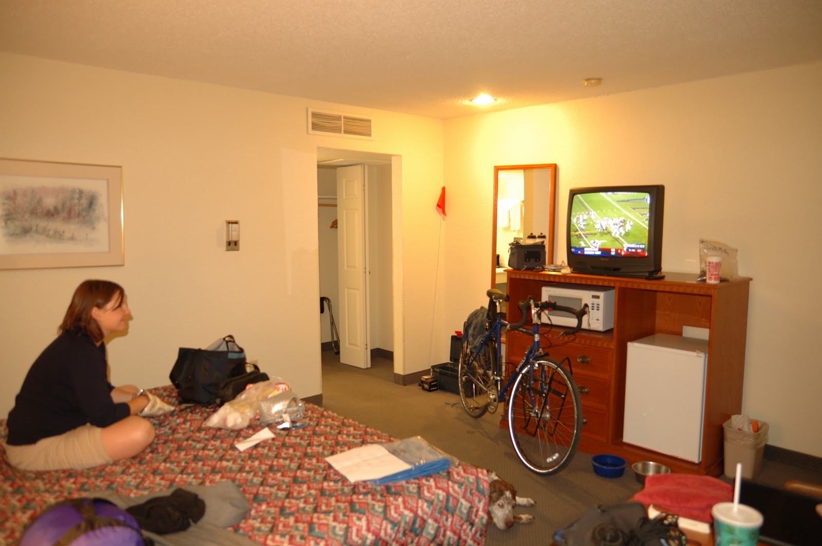
The scene at the Cow Palace Best Western here in Lamar, CO is one of anticipation...and gear. For the second night in a row I've amassed my pile of gear and now stare at it contemplating all of the options, considerations and hopes that everything that needs to be here is finally here and not sitting at home on the dinning room table.  I don't know if the magnitude of what lies before me has fully set in yet, but amidst my stack of stuff and an odd smelling hotel room its starting to hit me. Tomorrow I'm going to be dropped off in the middle of no where along the border of Colorado and Kansas and I'm going to ride west:  wow.  I guess I should get packing. Tomorrow I'll let you know how the massive 100+ mile day one goes...maybe the scene in Fowler will be different.
Chillin' at the Cow Palace, Kate, Bean and Bike